 BackCountry Navigator TOPO GPS PRO


Play in the outdoors with Android as your Handheld GPS and offline topo maps!
Read more
Play in the outdoors with Android as your Handheld GPS and offline topo maps!
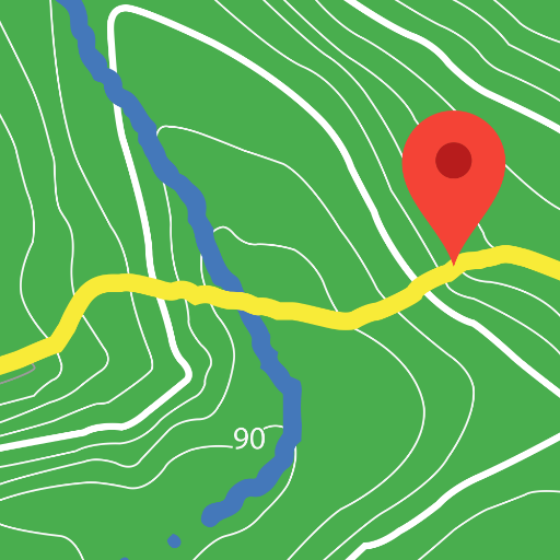
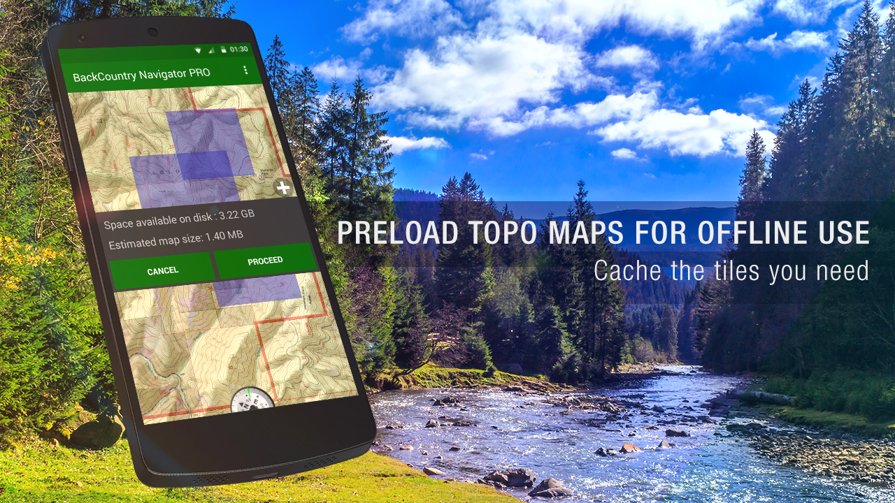
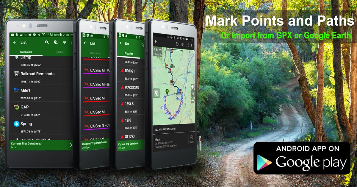
Download topo maps for an offline outdoor navigator! Use your phone or tablet as an offroad topo mapping handheld GPS with the bestselling outdoor navigation app for Android! Explore beyond cell coverage for hiking and other recreation. Download topo maps for the US and many other countries in advance, so you wont need cell coverage for navigation. Use storage memory for maps. New: Android Wear support to see navigation at a glance on wristUse GPS waypoints from GPX or KML files, or enter your own coordinates using longitude/latitude, UTM, MGRS, or grid reference. Using GOTO makes a waypoint a locus for navigation. This uses many publicly available map sources as free downloads. Some additional content available as an in app purchase:-Accuterra Topo Map Source for $19.99/year. This can be purchased and used with or in instead of the free sources.-Thunderforest Map Sources - worldwide for $7.99 per year. - Boundary maps for 12 western states from the Bureau of Land Management(BLM) Overlay for topo maps valued by hunters. -GMU boundaries in some states-Lake Contours in several states. -Content from US TrailMaps including:-ATV, Whitewater, and Equestrian Trail Maps See the menu under More-> "Purchasing AddOns". They can be shown on top of topo maps. You may try the DEMO version to make sure you like the maps in your country. About topo (topographic) maps: Topo maps show terrain through color and contours, and are useful for navigation offroad. Topo maps and GPS can be used for hiking, hunting, kayaking, snowshoeing, & backpacker trails. You can create your own maps with Mobile Atlas Creator, or specify a custom tile server. Built in sources include:OpenStreetMaps from MapQuest OpenCycleMaps showing terrain worldwide US Topo Maps from Caltopo and the USGSUSTopo: Aerial Photography with markup. Canada Topo Maps from ToporamaMarine maps: NOAA RNC Nautical Charts (coastal)USGS Color Aerial photography Topographic Maps of Spain and Italy Topo maps of New Zealand Japan GSI maps.Many of the above sources are generally free to use. Use offline topo maps and GPS on hiking trails without cell service. The GPS in your Android phone can get its position from GPS satellites, and you don’t have to rely on your data plan to get maps. Have more fun and safe GPS navigation in the backcountry.Use as a geocaching navigator by getting a pocket query as GPX. Besides geocaching, use GPS for recording tracks and GPS waypoints on your trip, all the while tracking your GPS quest on topographic maps. It may replace your Garmin handheld GPS. Here are some of the outdoor GPS activities BackCountry Navigator has been used for:As a hiking GPS both on hiking trails and off trail. Camping trips to find that perfect camping site or the way back to camp with GPS. Hunting trips for hunting wild game in rugged areas. Doing recon for a hunt or as your hunting GPS Fishing: make it your fishing GPS. Search and Rescue (SAR). Trekking the Pacific Crest trail or other long term hiking. Kayak and canoe treks on inland lakes and streams or marine, coastal waters. Backpacker trips: using topo maps of wilderness areas and national forests for navigation on trails with the GPS in your rucksack or backpack. Find your own ways to have fun in the outdoors. Be a maverick by venturing beyond cell service boundaries with your GPS. Become a pro at navigation with GPS for the outdoors. BackCountry Navigator has been on WM devices and preloaded on the Trimble Nomad outdoor rugged device. This Android version is more flexible, featured, and fun. Create a memory with maps. For a one time fee, this a great addition to the outdoor gear you bought at Cabelas, REI, or another outdoor store. Many have found the Android GPS in a phone or tablet to substitute for a Garmin GPS or Magellan GPS, such as the Garmin GPS units Montana, Etrex, or Oregon. Android can be your handheld GPS.Folder migration required for Android 11+ by Google. Fixes to folder migration. Ability to restart from settings. Other fixes for file handling. Find Premade OpenAndroMaps map files. Upload for users of bcnavxe.com.
Read trusted reviews from application customers
This used to be a great app, but at some point the GPS location and track recording functions stopped working correctly. Now my recorded tracks are wildly inaccurate, making the app virtually useless for me. Very disappointing.
Paid for pro then dev removed features
Was good now doesn't work, recommend try a different app
Pretty decent app for navigating while hiking. Not so much when navigating while Overlanding. Five stars for hiking. Two stars for Overlanding.
Great App, use it all over SE Alaska
This app worked extremely reliably for many years and has helped me on numerous outdoor adventures in the past. I prefered it above all other similar apps because it did not require me to create an account just to be able to use the app. After recent updates it has become completely unusable for me because it keeps displaying a message saying "Internet Off, See Layers Menu". I have confirmed that the "Internet Enabled" option is turned on. Reinstalling, clearing data/cache did not help.
Can't even find the folder on my android device to upload maps. App is junk don't waste your money
Not sure what these guys have done... i recently re-purchased the app (used other backcountry aps before) and have to also purchase the underlying map... what's the point of purchasing the app? So it can read the map that you also have to purchase? Unless I'm somehow mistaken, seems like a better idea to just purchase another app. Very poor communication on this. Might try out alltrails next time - definitely a different one.
Loved this app. Lost all my track info I had saved for years after the migrate thing showed up. Now looking for a new app. 😔
What happened to this app? I paid for pro and I've been using it for years. It used to be great. Got a new phone and went to use it while I was out on a walk and it took a few minutes of clicking through permissions and other nonsense before whatever that migration was that didn't work. Now it seems like the map sources aren't loading and a bunch are talking about subscriptions.. I'm going to find a new hike tracker.